While lake area homeowners are keeping an eye on floodwaters, two groups are using the emergency conditions for extra research.
The Watershed Foundation, which works to improve water quality by reducing sedimentation and nutrient loss, has spent time this week looking for signs of excessive sedimentation loss.
That’s often obvious in heavy brown floodwater, said Lyn Crighton, executive director for TWF.
Much of the work involves photographing and documenting the flow of brown water, which is carrying sediment downstream.
The tracking of heavy sedimentation flow can be the focus of future work with property owners, she said.
“With this much runoff, it’s a good opportunity to see where the biggest problems are,” Crighton said.
The photos could be used to let property owners better understand what’s happening with their land.
She noted that a lot of the land in the watershed is agricultural. “All that sediment coming off the fields is not good for them, either. That’s the topsoil and grows our crops.”
TWF, which has been in existence for more than 20 years, is also sharing the latest information with members and supporters of the watershed.
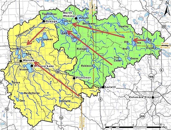
The watershed includes about 246 square miles, encompassing much of Kosciusko County as well as parts of Noble and Whitley counties.
The sharing of info is especially important for many summertime residents, Crighton said.
While conditions are ripe for research, Crighton was quick to note that as many struggle with the flooding, “I would not say there is an upside.”
Meanwhile, the Lilly Center for Lakes and Streams at Grace College is doing its own research, using students to take water samples, said Alex Hall, the assistant director for the organization.
The samples help determine what exactly is entering a handful of lakes and streams the group tracks.
More than 5 inches of rain has fallen within recent days, and melting snow has added to the flooding conditions.
“The unique rain events in recent days are a really good time to capture some good data, even though it certainly has an impact on people’s homes and businesses,” Hall said.
The students were busy taking “high flow” samples on Wednesday and Thursday, Hall said.
Lakes and Streams volunteers monitor 12 streams every other week. This week, there was an emphasis on extra sampling around Tippecanoe Lake, Oswego Lake, James lake, Syracuse Lake, Lake Wawasee and Winona Lake, Hall said.
Officials believed the Tippecanoe River would crest Saturday, but with more rain in the forecast, that might not happen until Monday or Tuesday, said Ed Rock, the emergency management director for Kosciusko County.
The National Weather Service predicted more rain for today and tonight, before a brief period of dry weather arrives.
Crighton said some homes in low-lying areas in the Barbee chain likely still face flooding.
One of those areas is on Bell Rohr Island on Oswego Lake, Crighton said.
The water gauge at the dam where Tippecanoe Lake dumps into the Tippecanoe River stood at 8.4 feet on Friday. That ranked as the 16th highest water level recorded over the past 66 years, Crighton said.
The current water level is considered moderate flooding, she said.
Flooding in March 2009 reached a major flood stage at 8.96 feet, which was the third highest level recorded since 1943, according to Crighton.


